Laraway Road at Union Pacific Railroad Crossing

Share Laraway Road at Union Pacific Railroad Crossing on Facebook Share Laraway Road at Union Pacific Railroad Crossing on Twitter Share Laraway Road at Union Pacific Railroad Crossing on Linkedin Email Laraway Road at Union Pacific Railroad Crossing link
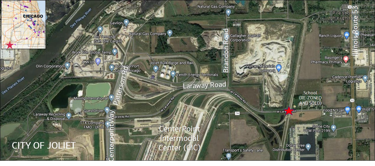
Current aerial view of Laraway road.

The Chicago Metropolitan Agency for Planning (CMAP) worked together with the City of Joliet and other stakeholders to study potential improvements at the Laraway Road at-grade crossing of the Union Pacific Railroad. The study also included the accompanying highway section from Brandon Road to IL Route 53 in the City of Joliet and the railroad section from Zurich Road to Schweitzer Road. The study identified a project purpose and need. The study subsequently identified an alternative to carry forward to phase-I engineering.

Project purpose and need

Engaging with partners and the public, the study team completed a "Transportation System Performance Report" and a "Stakeholder Survey." In consultation with our agency partners, the team refined this into a draft formal "Purpose and Need" statement. These documents are all available in the Documents section of this page.

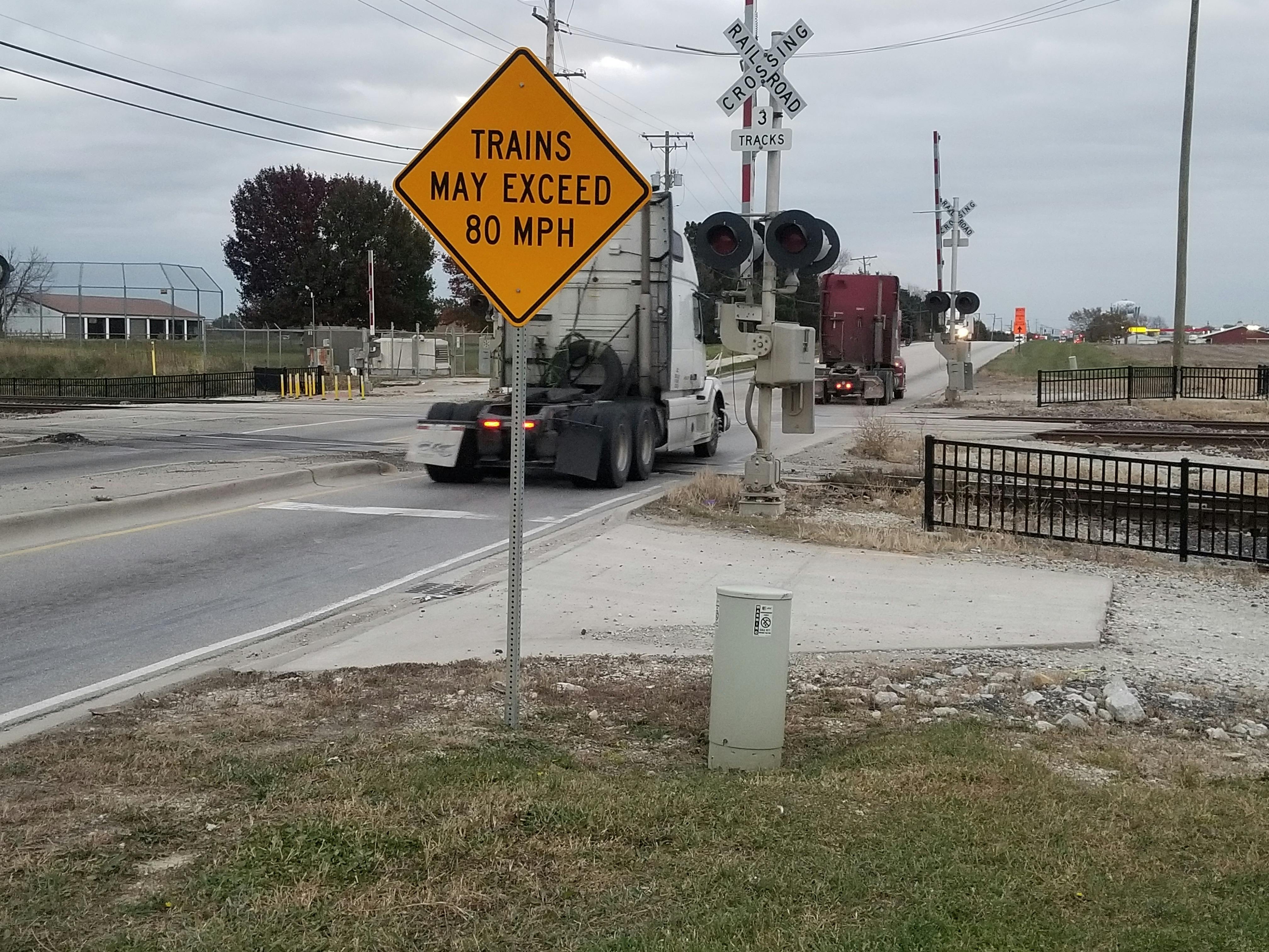
Identified needs. Laraway Road experiences delays and unreliable travel times which are expected to continue through the planning horizon (even with the Houbolt Road bridge construction). These are the result of 1) an extremely high volume of slow-moving trucks through this freight corridor, 2) extended gate closures at the UPRR crossing that often last greater than 10-15 minutes, 3) frequent vehicle safety stops at the UPRR that disrupt the flow of traffic, and 4) backups along Laraway Road eastbound from the IL 53 intersection that extend beyond the UPRR, which can result in vehicles stopped on the tracks when the gates close. This can be summarized into three main needs to be addressed: delay, safety, and freight network reliability.

Project purpose. The purpose of the project is to improve the efficiency of the study area’s transportation system by reducing travel delays along Laraway Road for all users caused by extended gate closures; to improve safety by reducing the potential for trains to collide with vehicles; and to improve the freight network reliability to the intermodal and industrial sites in the study area.

The final approval of the project purpose and need comes during the NEPA process.

Alternatives identification and evaluation

Alternatives were evaluated based on the following factors:

  • Laraway Road mobility and safety
  • Size of the transportation footprint
  • Maintenance of traffic during construction
  • Drainage and utility conflicts
  • Water resources
  • Magnitude of cost
  • Constructability

The study identified a range of solutions to address delay, safety, and freight network reliability. The alternatives included raising the railroad over Laraway Road, lowering the railroad under the road, raising Laraway Road over the railroad, or lowering the road under the railroad.

In addition to the grade separation, a number of improvements to the intersection of Illinois Route 53 and Laraway Road were analyzed. These included moderate improvements, such as additional turn lanes, but also included more extensive reconstruction of the intersection. Several innovative configurations, like roundabouts and continuous-flow intersections, were also evaluated.

Alternative to carry forward

The alternatives evaluation revealed that raising Laraway Road over the Union Pacific Railroad performed better than the other alternatives. This alternative may be carried forward to phase-I engineering. The remaining alternatives will not be carried forward.

The following improvements were included in each of the "build" alternatives and will be carried forward with raising Laraway Road over the railroad:

  • Widening and reconstruction of Laraway Road to two lanes in each direction from Brandon Road to IL 53. The right-of-way along Laraway Road varies from approximately 75-100 feet. In order to avoid impacts to the Joliet stormwater facility, the centerline of Laraway Road would be shifted to the south. This would result in an increase in right-of-way by approximately 20 feet to the south. Under the proposed condition, with a relocated Laraway Road centerline, 60 feet of right-of-way would be needed either side of the proposed new centerline.
  • 10-foot shared-use path (pedestrian and bicycle facility) provided on north side of Laraway Road
  • East of the old school property, 1/3-mile east of UPRR , a north-south roadway (Marcella Avenue) had been planned by the City of Joliet on existing right-of-way (and was recently constructed). For the PEL Study, which is based on a design year of 2050, the new road was considered an existing condition. Joliet recently added a traffic signal at the Marcella Avenue intersection with Laraway Road.
  • With the addition of the grade separation between Laraway Road and the railroad, new roadway connections to the existing railroad service roads are required. These connections would be south of Laraway Road, impacting agricultural land. Provides access to service roads along UPRR on east and west side of the tracks.
  • With the addition of the grade separation between Laraway Road and the railroad, a new roadway connection to the lift station would be required, impacting agricultural land. Access to lift station on northeast quadrant of the Laraway Road and UPRR crossing would be made via service road that intersects with Marcella Ave.

Three intersection configurations are also being carried forward forward for further evaluation.

The PEL study process

CMAP used the Planning and Environmental Linkages (PEL) process to complete this work. A PEL study is an early planning-level study process, developed and approved by the Federal Highway Administration. The PEL process allows consideration of environmental constraints, community concerns, and economic goals early in project planning and development. The benefits of the PEL process include reducing the duplication of effort in future studies, promotion of cost-effective environmental stewardship, and reduction of delay in project implementation.

The PEL final report was reviewed by federal and state partners, with a finding of no additional comment on July 19, 2022.

Next steps

The PEL Study has been completed. State and federal officials questions were addressed, leaving no further comments. The next step in the study process would be to initiate a locally-led environmental and preliminary engineering study. It would use the decisions regarding the project purpose and need, and alternatives to be carried forward as the starting point for the Engineering-I/NEPA study. In addition, the complete PEL Study stakeholder mailing list and comments will be transferred to the new study, providing a seamless transition between these efforts. The Illinois Commerce Commission has programmed $20 million toward this endeavor.

The City of Joliet, which would be the local sponsor, has not committed to additional studies or construction of this project. This PEL Study will help the City understand the cost and scope of the project, should the City choose to proceed.

Banner image source: Nearmap.

Discussions: All (6) Open (0)
  • Station 1: Introduction

    by Michelle Agunloye, almost 4 years ago
    Share Station 1: Introduction on Facebook Share Station 1: Introduction on Twitter Share Station 1: Introduction on Linkedin Email Station 1: Introduction link
    CLOSED: This discussion has concluded.


    This station provides an introduction to the Laraway Road project and examines the importance of undergoing the study.  


    Please share your comments on Station 1, the Introduction, below. 

    Replies Closed
  • Station 2: PEL Study Process

    by Michelle Agunloye, almost 4 years ago
    Share Station 2: PEL Study Process on Facebook Share Station 2: PEL Study Process on Twitter Share Station 2: PEL Study Process on Linkedin Email Station 2: PEL Study Process link
    CLOSED: This discussion has concluded.


    This station provides an overview of the Planning and Environmnetal Linkages (PEL) Study and the benefits of undergoing this process. 


    Please share your comments on Station 2, the Planning and Environmental Linkages Study Process, below.

    Replies Closed
  • Station 3: Project Needs and Public Input

    by Michelle Agunloye, almost 4 years ago
    Share Station 3: Project Needs and Public Input on Facebook Share Station 3: Project Needs and Public Input on Twitter Share Station 3: Project Needs and Public Input on Linkedin Email Station 3: Project Needs and Public Input link
    CLOSED: This discussion has concluded.


    This station provides a summary of the project's purpose and need as well as the first phase of public involvement on this project.


    Please share your comments on Station 3, the Purose and Need, and consider the following questions:


    Does the Purpose and Need statement capture your understanding of the issues on Laraway Road from Brandon Road to Illinois Route 53? (yes/no and please explain)


    Replies Closed
  • Station 4: Alternatives Considered

    by Michelle Agunloye, almost 4 years ago
    Share Station 4: Alternatives Considered on Facebook Share Station 4: Alternatives Considered on Twitter Share Station 4: Alternatives Considered on Linkedin Email Station 4: Alternatives Considered link
    CLOSED: This discussion has concluded.


    This station provides an overiew of the alternatives being considered.


    Please share your comments on Station 4, Alternatives, and consider the following questions:


    Does the recommended Alternative to Be Carried Forward for future studies address the Purpose and Need for the project? (yes/no and please explain)


    Are there any important issues or potential solutions that the study team needs to consider more carefully in this stage of the alternatives development and evaluation process?


    Are there other issues that project engineers and the City of Joliet will need to study more closely if the City decides to proceed to project engineering and construction?


    Replies Closed
  • Station 5: Details on Alternatives Considered

    by Michelle Agunloye, almost 4 years ago
    Share Station 5: Details on Alternatives Considered on Facebook Share Station 5: Details on Alternatives Considered on Twitter Share Station 5: Details on Alternatives Considered on Linkedin Email Station 5: Details on Alternatives Considered link
    CLOSED: This discussion has concluded.


    This station provides a detailed desctiption on the alternative designs being considered for the project. 


    Please share your comments on Station 5, Details on the Allernatives being Considered, below.

    Replies Closed
  • CMAP and the City of Joliet

    by Michelle Agunloye, almost 4 years ago
    Share CMAP and the City of Joliet on Facebook Share CMAP and the City of Joliet on Twitter Share CMAP and the City of Joliet on Linkedin Email CMAP and the City of Joliet link
    CLOSED: This discussion has concluded.

    CMAP, as the regional Metropolitan Planning Organization, is sponsoring the Planning and Environmental Linkages (PEL) Study through the federal coordination process and is providing the funding necessary to support this planning initiative. CMAP is working in coordination with the City of Joliet, the jurisdiction agency for Laraway Road. Through this PEL Study, the Purpose and Need and the results of the alternatives screening can be carried forward into the engineering phase, saving time and effort during that phase of project development. This PEL Study is also developing an early, planning-level cost estimate and an initial funding strategy, both of which can help the City decide whether the project should move forward.

    Replies Closed
Page last updated: 20 Jun 2024, 07:42 AM