
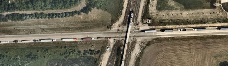
Frequently Asked Questions (FAQs)
- Four-quadrant gates, descending on the approach of a train. The near-side gates descend first, followed by the far-side gates. The four-quadrant gates prevent cars and trucks from going around closed gates if, for example, a train is approaching slowly.
- Flashing red lights warn of an approaching train.
- Advance warning signs. These signs warn drivers that a railroad crossing is ahead.
- Crossbucks mark the crossing.
- Multiple-track warnings indicate that three tracks are at the crossing.
- Pavement markings alert drivers that a railroad crossing is ahead.
- Stop bars identify the place for a safety stop or to wait when the gates are down or lights are flashing.
- Emergency notification signs show the Union Pacific's emergency phone number and the Laraway Road crossing ID (289771E).
- Z-pedestrian approaches force pedestrians to look in both directions before they cross the tracks.
- Pedestrian gates descend approach as the train approaches.
Why is this crossing being studied?
The Laraway Road crossing of the Union Pacific Railroad has safety challenges and congestion problems. Trains frequently block the crossing and impede traffic flow on Laraway Road. Sometimes traffic along Laraway Road backs up from the Illinois Route 53 intersection through the crossing, creating a potentially dangerous situation if traffic does not stop in advance of the crossing.
The location is important to commerce in the form of goods-carrying trucks and freight trains. The location is also important for passenger travel, since high-speed Amtrak trains traveling between Chicago and St. Louis use the Union Pacific tracks.
The crossing has been identified as one of 47 grade crossings prioritized for study or improvements in the Chicago region. See Northeastern Illinois Priority Grade Crossings.
What are the limits of the study?
The study will include the section of Laraway Road from Brandon Road to IL Route 53, including the Union Pacific Railroad at-grade crossing.
What is a PEL study?
Planning and Environmental Linkages (PEL) is a type of transportation planning study at a corridor level to link planning information directly to the National Environmental Policy Act (NEPA) environmental review process. A PEL study can include assessing the feasibility of projects and can determine whether there are feasible alternatives that satisfy the need for an improvement. To figure this out, the study will identify the project's purpose and need, identify and evaluate a range of alternatives to accomplish that goal, and estimate project costs. Agencies can achieve significant benefits from a PEL study including improved information sharing between agencies, reduction in the duplication of work between planning and NEPA, and an early opportunity for the public to provide meaningful into the study.
What happens after a PEL study?
That depends on the results of the PEL study. Three possible paths forward, include:
(1) The PEL study may recommend no action, in which case the crossing would continue to operate in its current configuration.
(2) A transportation management improvement may be recommended, such as photo enforcement to deter motorists from disregarding regulatory signs and crossing warning devices. In this case, the grade separation cannot move forward to implementation.
(3) If "build" alternatives are recommended to be carried forward, then the project would proceed to Phase I study, where detailed engineering can begin. The Phase I process would start where the PEL study left off, with the alternatives recommended for further study. The outcomes of the PEL process inform Phase I and NEPA studies, leading to a more informed and streamlined process.
For more detailed information about the Illinois Department of Transportation’s Project Process click here.
These sorts of projects usually involve meetings. What's the alternative during the health emergency?
CMAP and its consultant team are committed to meaningful public and stakeholder engagement for this project, to assure we understand the transportation issues and community values in the area and ask for your feedback throughout the process. While we are unable to conduct in-person meetings now, we are using online meetings, phone calls, and this site to engage the public.
What is an at-grade (or level) rail crossing or intersection?
Highway-railroad grade crossings are intersections where a highway crosses a railroad at-grade (on the same level). To avoid collisions, warning/control devices are required at grade crossings just like intersecting roads need stop signs or traffic signals.
Active Grade Crossings, such as Laraway Road, have active warning and control devices such as bells, flashing lights, and gates, in addition to passive warning devices such as crossbucks (the familiar x-shaped signs that mean yield to the train), yield or stop signs and pavement markings. Passive Grade Crossings which are typically located on roads with low volumes of traffic have only passive warning devices.
What is a rail grade separation?
A rail grade separation eliminates the conflict between the roadway traffic and railway trains by eliminating the at-grade rail crossing. To do this, the profile of one or both of the facilities is raised or lowered.
For the Laraway Road at-grade crossing with the railroad, several alternatives are proposed that would eliminate the at-grade crossing or intersection. These include
- raising the road with a new bridge over the railroad.
- lowering the road with an underpass under the railroad.
- raising the railroad with an embankment over Laraway Road.
- lowering the railroad with an underpass under Laraway Road.
How much will the project cost?
Cost estimates have not yet been prepared, but rough estimates of cost will be developed for “build alternatives” recommended to be carried forward to future studies at a later point in the study. Planning level cost estimates will be shared with the public.
How will the project be paid for?
Transportation improvement projects are typically paid for with a mix of local, state and federal funding. Improvements involving a railroad sometimes include funding from the railroad owner or the Illinois Commerce Commission. Further, some highway improvements are financed by tolls, such as the proposed Houbolt Road Bridge over the Des Plaines River. Project funding options will be considered after the completion of the PEL study.
How much road traffic is there per day on Laraway Road?
In 2016 the annual average daily traffic estimate (AADT) for Laraway Road was 10,700.
CMAP conducted a traffic count at Laraway Road in 2018 and found 8,656 total vehicles, consisting of 2,095 light-duty vehicles (e.g., passenger cars, SUVs, and pickups); 1,626 single-unit trucks; and 4,936 combination trucks (e.g., tractor semi-trailers and tanker trucks).
Approximately 75 percent of the vehicles at this location are trucks, which is extraordinary, although not surprising as Laraway Road provides access to CenterPoint Intermodal Center and several other major industrial sites. Principal arterials in an urban area typically carry approximately 10 percent trucks.
Won't the Houbolt Road Bridge, when it is built, take the road traffic away from Laraway Road?
Houbolt Road is expected to carry a lot of traffic, but traffic on Laraway Road is expected to keep growing over the next several decades. By 2050, CMAP traffic models indicate that traffic will be 50% higher than today, even with the Houbolt Road Bridge. Joliet is expected to continue strong job and commercial growth.
How much train traffic is there each day on the Union Pacific Railroad at the Laraway Road crossing?
CMAP observed train volumes for a day, using a traffic video camera. Over 24 hours, 10 Amtrak trains, 6 freight trains, and 6 switching freight trains, were observed for a total of 22 trains. The gates were activated a total of 25 times (this includes false activations and single activations for multiple trains).
How long do trains block the road?
The train closures are comprised of a system of activities starting with flashing warning lights, followed by gate closures, and then ultimately the passing of train through an at-grade crossing. In general terms, a passenger train is typically shorter and moves at higher rate of speed than a freight train.
Along this line, a typical Amtrak train will require an approximate two to three-minute gate closure, including the initial warning lights. Freight trains are usually longer and slower; they require a 6 to 10-minute closure. Within this crossing area, there is also a spur track which can cause even greater gate closures as freight trains are slowly entering or exiting the intermodal facility.
A gate closure that lasts for more than a few minutes can result in extended traffic queues on Laraway Road that take several minutes to clear up and return to normal traffic flow. Eastbound backups are exacerbated by the proximity to the Illinois Route 53 intersection, where the number of trucks that can get through is limited for each signal cycle.
If a big part of the problem is the length of time the crossing is blocked, can't we prohibit the railroads from blocking the crossings for so long?
The movement of freight trains are governed by federal laws. The State of Illinois used to have a law in effect to limit crossing blockages to 10 minutes. However, the law was overturned by the Illinois Supreme Court because it conflicted with a federal law giving the Federal Railroad Administration authority to regulate rail safety. Requiring a train to move when another regulation (e.g., crew service hours) required the train to stand was found to infringe on federal authority. So, the law was overturned.
How fast do trains go at Laraway Road?
The Union Pacific Railroad's Joliet and Springfield Subdivisions have been designated a high-speed rail corridor by the Federal Railroad Administration and the Illinois Department of Transportation. This corridor extends from Laraway Road to Alton Illinois, near Saint Louis. In this corridor, the Union Pacific has installed an Incremental Train Control System ("ITCS") and other safety improvements. The current maximum time-table speed throughout the corridor is 60 mph for freight trains and 79 mph for passenger trains. The track in the corridor has been upgraded to support speeds up to 80 mph for freight trains and 110 mph for passenger trains. Passenger train speeds are expected to reach 90 mph in 2020, with speeds up to 110 mph anticipated.
What safety features are already in place or planned for the at-grade rail crossing?
The Laraway Road crossing has been improved several times over the past decade. The safety features in place now include the following:
Many commercial vehicles (e.g., buses and vehicles containing hazardous materials) are required to complete safety stops in advance of railroad crossings, including Laraway Road. In addition, federal regulations (49 CFR 392.12) require safe clearance, that is "no driver of a commercial motor vehicle shall drive onto a highway-rail grade crossing without having sufficient space to drive completely through the crossing without stopping."
Despite all of this, passenger vehicles and trucks can still routinely be found sitting in the railroad crossing, blocked from moving ahead, creating a grave danger for motorists and people on approaching trains.
In order to address identified safety concerns, the Illinois Commerce Commission (ICC) is considering short-term, emergency safety improvements in a separate and distinct process. These include the installation of Queue Cutter signals along Laraway Road eastbound in advance of the four quadrant gates to pre-emptively stop traffic when loop detectors indicate that there is a potential queue extending from the IL Route 53 intersection that could backup through the at-grade crossing. CMAP is coordinating with the ICC.
How will impacts to social and natural resources be considered in the PEL study?
Environmental data from available public records and coordination with resource and regulatory agencies will be part of the PEL decision-making process. Environmental impacts will be evaluated in greater detail during the Phase I Study in compliance with the National Environmental Policy Act.
I use Laraway Road a lot to drop off loads near Illinois Route 53. Will Laraway Road close for construction?
At this stage of design, we are developing roadway alternatives that would maintain one lane of travel in each direction along Laraway Road during construction. No alternatives are being developed that would eliminate access to properties west of the at-grade rail crossing. Methods to maintain traffic flow vary based on the alternative, but could include use of temporary pavement, slight shifting of the Laraway alignment, and temporary detours to other roads to safely accommodate certain construction activities, i.e. beam placement. In addition, the new Houbolt Road Bridge is anticipated to be under construction as early as summer 2020 which could provide alternative access to this area during construction.
Following the PEL Study, if this project is selected for a Phase I Study, a traffic management plan (TMP) plan would be developed for the build alternative that would describe how traffic flow is proposed to be maintained during construction.
Roads to the north and south, like Zurich and Schweitzer, prohibit large trucks. Will these road open to trucks during construction?
At this stage of design, we are developing roadway alternatives that would maintain one lane of travel in each direction along Laraway Road during construction. No alternatives are being developed that would eliminate access to properties west of the at-grade rail crossing. Methods to maintain traffic flow vary based on the alternative, but could include use of temporary pavement, slight shifting of the Laraway Road alignment, and temporary detours to other roads to safely accommodate certain construction activities, i.e. beam placement. In addition, the new Houbolt Road bridge is anticipated to be under construction as early as summer 2020 which could provide alternative access to this area during construction.
Following the PEL Study, if this project is selected for a Phase I Study, a traffic management plan (TMP) plan would be developed for the build alternative that would describe how traffic flow is proposed to be maintained during construction.
I own property adjacent to the crossing. Will I still have access to the property after the project?
For the PEL Study, a range of alternatives are being considered that would change the elevation of either Laraway Road or the Union Pacific Railroad line to create a grade separation. Wherever feasible, driveway access would be retained in its current location. However, if a change in elevation along Laraway Road results in the driveway becoming too steep to safely access the property, it would be shifted to a location where safe ingress and egress is feasible. The cost to relocate the driveway access would be part of the overall project costs. Once a final build alternative is determined during a future Phase I Study, that project team would coordinate directly with the property owner regarding any proposed changes in driveway access.